The criteria developed by the IUCN to evaluate risk levels of terrestrial ecosystems have been applied in the country for the first time.
Ecosystems provide the ecosystem services that are basic for human well-being, so knowing about their current conditions is relevant for society. If ecosystems are severely transformed or degraded, living conditions for communities that benefit from these ecosystems, along with national development goals, will be affected1
With the aim of evaluating ecosystem threat status and supporting processes of decision-making and management, the International Union for Conservation of Nature (IUCN), through the Commission on Ecosystem Management, designed a worldwide methodology for assessing ecosystem collapse risk in a quantitative and standardized manner2. This resulted in the Red List of Ecosystems (RLE), a tool directed towards evaluating risks, detecting threats and early alerts, prioritizing conservation areas, identifying ecological restoration and monitoring climate change. The criteria used for assessment include: reduction in geographic distribution (criteria A and B) and the degradation of essential biotic processes and components (criteria C and D). In this way, the ecosystem classification in the RLE follows similar categories to those in the Red List of Species.
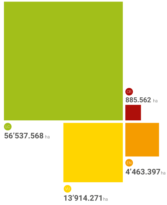
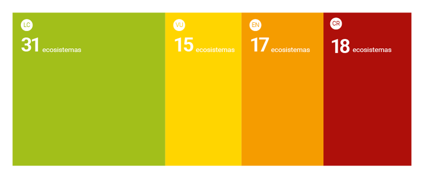
This first nationwide application of RLE is based on a map of potential ecosystems that distinguishes 81 terrestrial ecosystems3. The assessment revealed that around 50% of the types of ecosystems identified in the country are in threat categories, either critically endangered (CR) or endangered (EN), and the determining aspect for these categorizations is the criterion of distribution area reduction (A). The most important drivers of area reduction include the expansion of agricultural frontiers and the lack of conservation of the remaining ecosystems that are found in rural and urban landscape mosaics around the country. The most affected regions are the Caribbean and the Andes, and it is foreseen that other threats, such as climate change, will have a greater effect in the same regions due to a reduction in water availability and the effect of climate change on biotic processes1.
This first assessment provides new elements to be considered in public politics because it identifies the ecosystems that are in serious risk and consequently require immediate management. On the other hand, the assessment opens new research and permanent revision opportunities about the available information that is based on the criteria and indicators established by RLE methods. In this sense, a national process of periodic updates should be consolidated in order to promote alliances between governmental institutions and research institutes. In that way the initiative may continue to be strengthened and developed.
 DOWNLOAD FILE IN JPG