305

The Protection of Paramos

Public, private, and community strategies

Margarita NietoInstituto Alexander von Humboldt Jessica ZapataInstituto Alexander von Humboldt Alejandra OsejoInstituto Alexander von Humboldt Paula UngarInstituto Alexander von Humboldt Julia MendozaInstituto Alexander von Humboldt

There are numerous strategies for protecting paramos. Although not all of them are acknowledged by the Colombian State, their role in ensuring the population's well-being and conserving biodiversity is crucial.

The 2,906,135 ha of paramo in Colombia (according to 1:100,00 scale cartography1)have been protected by the government and society through many legal figures and social agreements.

In addition to the conservation categories in the National System of Protected Areas (SINAP for its initials in Spanish), other conservation measures exist. These are complementary conservation strategies and other figures that, despite being conceived for collective land-use planning instead of conservation, also contribute to the protection of the territory. From the latter some community management figures acknowledged by the State are highlighted: Indigenous Reserves, Lands of Afro-descendant Communities, and Lands of Peasant Communities.

The 151 protected areas of the SINAP in paramos, run either by governmental or private entities, cover a total of 1,297,492 ha, an area equivalent to 45% of the total of paramo ecosystems in the country. Some of these protected areas are for strict conservation thus have clear use prohibitions and no possibility of exploitation (38% of paramo areas). Other areas allow sustainable use, exploitation, or boundary relocations (8%).

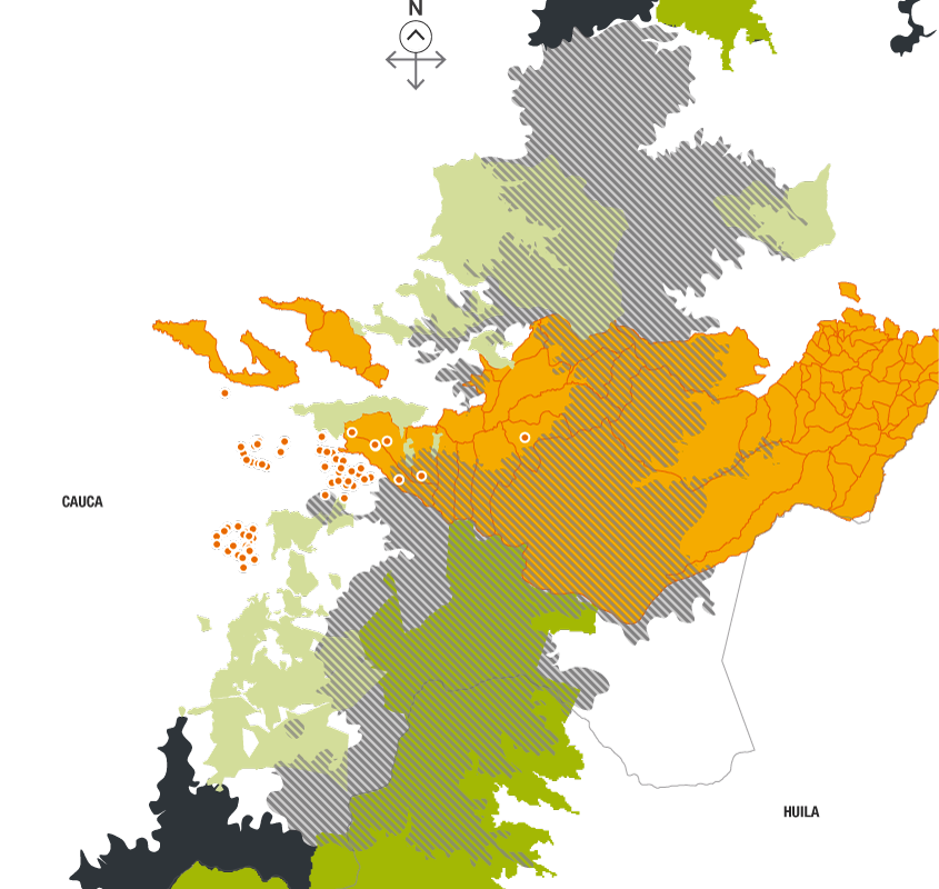
On the other hand, complementary conservation strategies include, for example, the Forest Reserve Zones of the Second Act, which cover 40% of the area of Colombian paramos. Other examples of complementary strategies present in paramos have international recognition: the Biosphere Reserves, Ramsar Sites of Wetlands of International Importance, and Important Bird Areas (IBAs). Yet there is no consolidated nationwide information that collects all the existing complementary strategies. Strategies such as Civil Society Nature Reserves that are not registered or environmental zoning strategies in municipalities or community territories are usually not included. However, it is important to consider them as opportunities to govern the territory. Figures of community management (Indigenous Reserves, Lands of Afro-descendant Communities, and Lands of Peasant Communities) are forms of land-use planning with explicit environmental components. Actually, according to the Incoder, in paramos there are 31 Indigenous Reserves belonging to 16 different ethnicities and 2 established Lands of Peasant Communities2-4.But this official information does not register the totality of occupied or reclaimed paramo territories of indigenous, peasant, and afro-descendant peoples. Such is the case of the complex Guanacas-Puracé-Coconucos, located in the states of Cauca and Huila, where indigenous and peasant communities converge. The information produced by Incoder2, states that in the complex there are 8 Indigenous Reserves in 13% of the area; instead, the information produced through consultation by the Ministry of Interior for the same complex reports 13 Indigenous Reserves with their respective councils. Apart from the conflict of incompatibility between official reports, the divergence reveals the scarce recognition of indigenous presence and their territorial aspirations in the area. Other non-official sources additionally recognize the presence of 8 peasant organizations that are in the process of establishing Lands of Peasant Communities. Likewise, in the area there are Civil Society Nature Reserves that have not been registered in the National Register of Protected Areas (RUNAP for its initials in Spanish)5. In sum, this scenario requires inclusive and legitimate governance. Therefore all the public, private, and communal initiatives and territorial figures, including those in process of being established, that contribute to the conservation of this areas must be recognized.

Zonas de Reserva Forestal

40% del área de páramo está en Zonas de Reserva Forestal (Cocuy, Central, Sierra Nevada de Santa Marta, Motilones, Amazonia y Pacífico) con 1.171.149 ha

44% de la superficie de estas ZRF está en Zona A (restricción total de actividades productivas).

Zonas de protección y desarrollo de los recursos naturales renovables

Una zona que cubre 99% del complejo de páramos de Perijá.

Protected areas of Sinap and paramos
Source: Runap (2015)
    • Civil Society Nature Reserves
    • Areas of the National Natural Parks System
    • Paramo complexes
Strict conservation without possibility of exploitation (national and regional):

21 resguardos, de 16 etnias diferentes, que cubren

40% of the total area of paramos is in Forest Reserve Zones (Cocuy, Central, Sierra Nevada de Santa Marta, Motilones, Amazon, and Pacific) with 1,171,149 ha.

44% of these FRZ is in A Zones (total restriction of productive activities)

Other protected areas, with permission for sustainable use and restoration, and subject to exploitation and boundary relocation:

116 protected areas with 226,042 ha

8% of the total area of paramos in Colombian

Some complementary conservation strategies in paramos
Source: MADS (2015)
    • Ramsar Sites
    • IBAs
    • Paramo complexes

    • Forest Reserves of the Second Act

    • A Zones

      A Zones guarantee the maintenance of ecological processes that ensure the provision of ecosystem services.

    • B Zones

      B Zones are areas with suitable land covers for the sustainable management of forest resources.

    • C Zones

      C Zones offer suitable conditions for productive agroforestry and silvopastoral systems and other activities that are compatible with the goals of the forest reserve.

    • Areas with previous land-use planning decisions
According to Incoder (2015), in Colombian paramo areas there are

31 Indigenous Reserves, belonging to 16 different ethnicities, that cover

290.360 ha and are mostly located in paramo complexes of the southern Andes (Cauca, Nariño, Huila) and the paramos of Boyacá, Santander, Norte de Santander, Magdalena, Cesar, and La Guajira.

2 Lands of Peasant Communities (APC) cover

19.563 ha in the complexes of Cruz Verde-Sumapaz and los Picachos.

6 Lands of Afro-descendant Communities (AAC) cover

14.610 ha in the complexes Cerro Plateado and El Duende in the western Andes mountain range.

Figures of territory management in the paramo complex of Guanacas-Puracé-Coconucos.
Source: Incoder (2015), ACIT- Incoder (2013), and RUNAP (2015)
Indigenous Reserves
Established Lands of Peasant Communities
Areas of the National Natural Parks System
Civil Society Nature Reserves
Paramo complex of Guanacas-Puracé-Coconucos
Other paramo complexes
State limits
According to Incoder (2015), in Colombian paramo areas there are

31 Indigenous Reserves, belonging to 16 different ethnicities, that cover

290.360 ha and are mostly located in paramo complexes of the southern Andes (Cauca, Nariño, Huila) and the paramos of Boyacá, Santander, Norte de Santander, Magdalena, Cesar, and La Guajira.

2 Lands of Peasant Communities (APC) cover

19.563 ha in the complexes of Cruz Verde-Sumapaz and los Picachos.

6 Lands of Afro-descendant Communities (AAC) cover

14.610 ha in the complexes Cerro Plateado and El Duende in the western Andes mountain range.

Indigenous Reserves, Lands of Afro-descendant Communities, and Lands of Peasant Communities present in paramo complexes.
Source: Incoder (2015)
    • Lands of Peasant Communities
    • Indigenous Reserves
    • Lands of Afro-descendant Communities
    • Paramo complexes

304

305

306

TOPICS

PARAMOS COMMUNITIES SINAP COMPLEMENTARY CONSERVATION STRATEGIES