Some initiatives of integrated management of biodiversity and ecosystem services in Colombia have been developed based on planning units of biophysical (p.e. basins) or political (p.e. municipalities) aspects, assuming that these are appropriate units for such purpose1,2.
The Humboldt Institute has been implementing a methodology of territorial management that is based on the integrated valuation of ecosystem services3. The methodology originates in the perception of the territory as a socio-ecological system in which the relationships and interdependence of ecosystems and human societies is identified2. Such socio-ecological focus is converted into a conceptual and methodological tool for analyzing interrelations of systems. Due to its versatility, it may be implemented in different areas and contexts. This is a key and necessary aspect for integrated territorial management and the prevention of environmental conflicts.
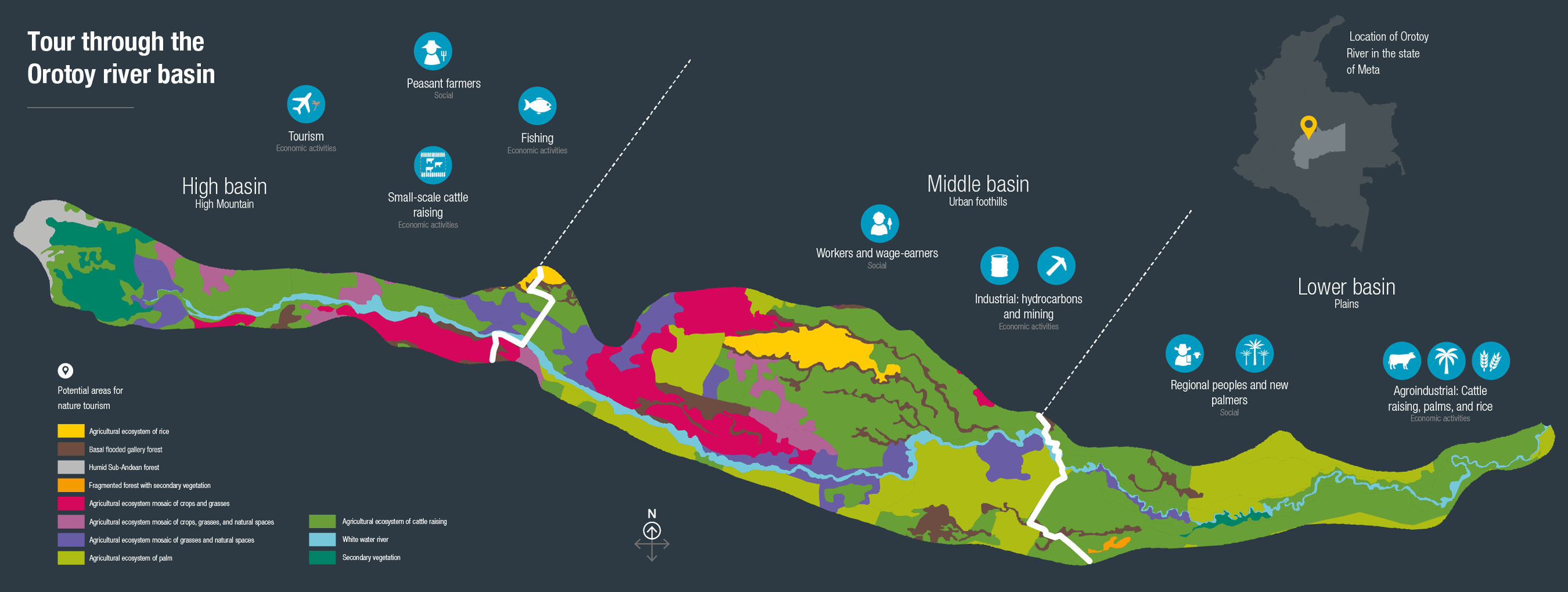
An example is the basin of the Orotoy River, which
is located in the Orinoquía. In the basin three different
socio-ecological systems exist: 1. A system in the higher part, with high mountain ecological functions where the
greatest amount of forests and areas of water provision
are found. This part is inhabited by small landowners and
peasants dedicated to small-scale cattle raising, fishing,
and recreation and tourism in the river. 2. The system
of the middle zone, where petroleum extraction and
palm and cattle agricultural systems in the foothills are
predominant. There are dynamics of urban and industrial
expansion where communities resemble urban centers,
and workers associated with the hydrocarbons sector
have settled. 3. A system in the lower part of the basin
where there is a landscape characteristic to the Llanos
Orientales. It is dominated by the expansion of palm and
cattle agricultural systems and contains a rural population
dedicated to traditional activities of cattle raising and rice
crops, even if there is a large and new floating population
that arrives with surges in the palm oil industry.
It is evident that the characteristics of socio-ecological
systems inside the basin are not homogeneous.
Nevertheless, the ecological connection between the
systems, and especially the links between ecosystem services of water regulation or quality and the cultural
similarities between the zones, must not be ignored.
As a result of such connections, there currently is a
growing demand for ecosystem services that has caused
environmental conflicts between local and regional actors,
chiefly those linked to productive activities and the use of water resources5. Conflicts may be addressed from a
socio-ecological systems perspective to develop actions
of conflict resolution, increase the adaptive capacity6 of each system, and reduce the risk of degradation or
collapse of ecosystems and their associated services7.
Using such socio-ecological perspective may function
as a response to address or prevent environmental
conflicts because it considers a broad set of variables in
planning that allow for greater detail of the territory.
 PDF version
 Methods (in Spanish)
 References
 Share
Share